A Greater Vision for a Great Park: Volunteer Today
Since 1989, Forest Park Conservancy has led the way to protect this natural treasure, By forming partnerships and building awareness, we are helping maintain Forest Park’s health and preserve its legacy for generations to come. Click the link above if are interested in volunteering or making a donation to FPC.
FPC has four key goals:
- STREAMS: Protecting and improving water quality in the Park’s more than 30 miles of streams, to safeguard watershed functions and human health
- CONNECTIVITY: Improving the connectivity between Forest Park, the Tualatin Mountains, the Coast Range and the Willamette River.
- FORESTS: Improving forests to support diversity, environmental integrity, connectivity and complexity.
- WILDLIFE: Maintaining and protecting native wildlife diversity The GFPCI is a significant undertaking in many ways. In addition to identifying needed restoration efforts inside the Park, the GFPCI recognizes the importance of the larger link between Forest Park and the Coast Range. The GFPCI also calls for protection and restoration efforts in areas immediately adjacent to the Park, to help stop the continual re-infestation of invasives and other threats from the outside of the Park’s boundaries.
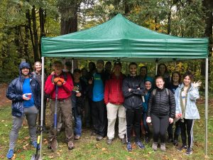
When you become a volunteer with FPC, they train and lead educational hikes in the park. This is a great way to learn about the native plants and species to the area. You will also learn how to:
- repair and maintain trails and bridges
- remove invasive weeds
- plant native trees and shrubs
-
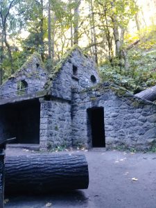
Stonehouse 
Biking in Forest Park 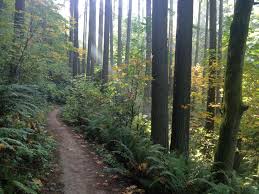
Wildwood Trail
TRAILS: Based on level of difficulty
EASY TRAILS
Lower MacLeay Trail
For the Forest Park beginner, Set in a lush canyon alongside the cool waters of Balch Creek, the largest stream in Forest Park, Lower Macleay Trail is an explosion of licorice ferns, leafy salal bushes, moss-jacketed hemlocks, and some of the most impressive fir specimens in the park, including Portland’s most gasp-inducing heritage tree, a 242-foot, jade-crowned giant—the country’s tallest fir within a city. For more color, scope out the creek’s population of native cutthroat trout. Then explore the “Stone House,” the remains of a Works Progress Administration–era structure, built in 1936.
Audubon Society Loop
A mile-long loop trail meanders along Balch Creek just off NW Cornell Road, More than 40 species of birds, including warblers, grosbeaks, and sparrows, have been recorded here. Bird-happy crowds typically head north from the parking area to the Pittock Bird Sanctuary.
Founders Trail
Take Founders Trail to North Collins Trail loop and return the way you came. (Easy, 2-mile lollipop loop) This trail is located in the 34-acre Uhtoff Sanctuary. It is especially noteworthy. Nicknamed “Pileated Woodpecker Alley,” it’s packed with abundant snags, a siren’s song to North America’s largest woodpecker. Tour the on-site Wildlife Care Center, home to Audubon’s fleet of educational birds, including falcons and owls.
Nature-Wildwood Loop
Turn off NW 53rd Drive onto Forest Lane, where you’ll find a few parking spots at the gate to Firelane 1. Take Firelane 1 to the picnic tables. Go past the junction with the Wildwood Trail, staying straight to take the Nature Trail. (Easy, 2-mile lollipop loop) Dreaming of a woodland picnic? Stuff your wicker basket and follow flat, wide Firelane 1 to two sets of mossy picnic tables. Walk off that charcuterie and Champagne by following the serene Nature Trail down to a leafy gully and across a footbridge over Rocking Chair Creek, eventually returning via the Wildwood Trail to Firelane 1.
MODERATE TRAILS
Dogwood Loop
From NW 53rd Drive, take Dogwood Trail. Turn left on Leif Erikson and go left up Alder Trail. Turn left on Wildwood Trail. Return via Keil Trail. (Moderate, 3-mile loop) For a post-workday jaunt, it’s tough to beat this easy loop just off NW 53rd, a 15-minute drive from downtown. After the small parking area, keep left up the narrow Dogwood Trail, and then fork right to stay on Dogwood. The path levels out under a canopy of Doug fir and bigleaf maples—peek between the trees for views of the Willamette and the industrial riverfront below. In spring, keep your eyes open for yellow woodland violets and trilliums galore, while summer means candy flowers, fairy bells, and false Solomon’s seal.
Firelane 15-Wildwood Loop
From NW Skyline Boulevard, follow Firelane 15, cross over the Wildwood Trail, and turn up Firelane 12 to BPA Road. Go right on BPA Road. Turn right on Wildwood Trail. Return via Firelane 15. A signed path to Kielhorn is roughly 0.6 miles past the Skyline entrance. (Moderate, 4-mile lollipop loop) Start on Firelane 15’s high ridgeline entrance off Skyline, with hazy views of the Willamette peeking through a powerline corridor and the stunted peak of St. Helens beyond. Drop down to gurgling Miller Creek, up through thick, mossy old-growth, and pop back on the Wildwood’s narrow, serpentine trail. Don’t miss the path to secluded Kielhorn Meadow, a grassy knoll where you might peep an elk grazing, if you’re quiet.
EXPERT TRAILS
Maple Trail Loop
From Saltzman Road off of Highway 30, turn left up Maple Trail. Pass Maple Tie Trail and turn right on Wildwood Trail. Descend Koenig Trail and return via Maple Trail. (Hard, 6-mile lollipop loop) Little-known fact: nearly three-quarters of the forest of Forest Park is bigleaf maples and red alders—not Douglas firs. Nowhere is this deciduous umbrella more delightful than along the aptly named Maple Trail. In fall, groves of bigleaf maples here rain down piles of crimson-and-gold leaves. But the Maple Trail hikes well in the dog days of summer, too. The 2.6-mile section between lower Saltzman Road and the Wildwood Trail bisects densely wooded canyons peppered with hemlocks and firs, and fords the shimmery waters of Saltzman Creek.
Tolinda Trail to Waterline
From NW Germantown Road, take Tolinda Trail. Go left at Leif Erikson and right up Waterline Trail. Return the same way. (Hard, 3 miles out-and-back) The Tolinda Trail takes its name from the site of a former Camp Fire Girls camp in the park. But make no mistake: this is one tough cookie of a hike. In less than a mile, the route vaults nearly 400 feet up to Leif Erikson. Temper first-degree thigh burns by enjoying bright blazes of fireweed, numerous lilies, and a welcome shot of solitude. To earn a merit badge for pluck, proceed up the Waterline Trail, a steep, often muddy route that ascends along a ridge to a water tower set in a sunny meadow atop Skyline Boulevard.
Ridge Trail
From a parking area at the end of NW Springville Road off of Skyline Boulevard, follow Firelane 7 and turn left down the Ridge Trail. Return the same way. (Hard, 3.5 miles out-and-back) Savor an unforgettable glimpse of one of Portland’s most photogenic bridges at the bottom of the Ridge Trail. The narrow path drops nearly 1,000 vertical feet from Firelane 7, near Skyline Boulevard, amid a quiet, seldom-visited section of the park. Just past Leif Erikson, pause to rest on a rough-hewn bench carved from a log, then exit the woods above Highway 30. Here maple and ninebark limbs frame a close-up portrait of the sea-green arches of the St. Johns Bridge towering over the Willamette.
Also to get you going on your hike… A little upbeat music : Lifehouse – Between the raindrops Feat. Natasha Bedingfield
Citation

Web address: https://www.pdxmonthly.com/articles/2017/5/15/eight-essential-forest-park-hikes
Author's of the page: Benjamin Tepler, Rebecca Jacobson, and Brian Barker
Website name: Portland Monthly
Title of the article: 8 Essential Forest Park Hikes
Publication Date: June 2017
Forest Park’s Historical Highlights

1803
- The first European explorers arrived in the Willamette Valley with the Lewis & Clark expedition.
1850s
- Forest Park is divided into land claims by settlers, with plans to clear the forest and build houses.
- Danford Balch settles 350 acre homestead in the Balch Creek watershed.
1903
- Renown landscape architecture firm, Olmsted Brothers recommends the Forest Park plan.
1914
- Hillside Drive (now Leif Erikson Drive) is built to provide access to planned developments.
1929
- Architect Ernest F. Tucker designs the Macleay Park Shelter (Stone House)
1948
- The City of Portland formally dedicates 4,200 acres of land as Forest park on September 25, 1948.
- Multnomah County turns over 2,000 acres acquired through delinquent taxes.
1951
- Largest fire in Forest Park’s history burns 1,200 acres north of Saltzman Road.
1976
- Wildwood Trail is designated a national recreation trail.
1989
- Friends of Forest Park is founded as a nonprofit organization to rally volunteers and donations to help care for the park.
- Friends of Forest Park raises funds to purchase 73 acres Keilhorn property, north of Forest Park.
1995
- Comprehensive natural resources management plan is established for how to protect Forest Parks natural habitat.
2008
- Friends of Forest Park officially becomes the Forest Park Conservancy.
2013
- The greater Forest Park conservation initiative (GFPCI) launches, a collaborative effort led by FPC to bring Forest Park back to health.
2015
- First large-scale invasive Ivy treatment is completed in partnership with Portland Parks & Recreation on 217 acres in the Balch Creek Watershed.
2018
- On September 25, 2018, Forest Park Celebrated its 70th Anniversary.